Warnow(MV750T).png

Size of this preview:
471 × 600 pixels
.
Other resolutions:
188 × 240 pixels
|
377 × 480 pixels
|
985 × 1,254 pixels
.
Summary
| Description |
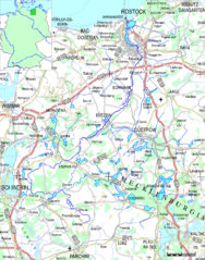
Deutsch:
Ausschnitt aus der Übersichtskarte von Mecklenburg-Vorpommern 1:750.000, Stand 09/2011; Farbbearbeitung zur Hervorhebung der Warnow und ihrer Nebenflüsse, sowie durchströmter Seen.
English:
Cut of the survey map of Mecklenburg-Vorpommern 1:750.000, recoloured to emphasizy Warnow river and its affluents and passed lakes.
|
| Date | |
| Source | http://www.laiv-mv.de/land-mv/LAiV_prod/LAiV/_AfGVK_alt/_atkis/atkis_dtk_gebiet_750mv.jsp#%DCbersichtskarte |
| Author | Landesamt für innere Verwaltung Mecklenburg-Vorpommern, Amt für Geoinformation, Vermessungs- und Katasterwesen |
Licensing
This file is licensed under the
Creative Commons
Attribution 3.0 Germany
license.
-
You are free:
- to share – to copy, distribute and transmit the work
- to remix – to adapt the work
-
Under the following conditions:
- attribution – You must give appropriate credit, provide a link to the license, and indicate if changes were made. You may do so in any reasonable manner, but not in any way that suggests the licensor endorses you or your use.
