Western_Germany_1923_en.png

Size of this preview:
370 × 599 pixels
.
Other resolutions:
148 × 240 pixels
|
296 × 480 pixels
|
474 × 768 pixels
|
632 × 1,024 pixels
|
1,406 × 2,276 pixels
.
Summary
| Description |
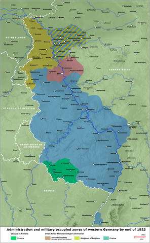
English:
Map - Administration and military occupied zones of western Germany by end of 1923
Deutsch:
Karte - Verwaltung bzw. Besatzung der westdeutschen Gebiete, Ende 1923
|
| Date | |
| Source | several contemporary illustrations/verschiedene zeitgenössische Darstellungen |
| Author | Lothar Velling, Relief: maps-for-free.com |
| Other versions | German Version , Arabic Version |
Licensing
|
|
I, the copyright holder of this work, release this work into the
public domain
. This applies worldwide.
In some countries this may not be legally possible; if so: I grant anyone the right to use this work for any purpose , without any conditions, unless such conditions are required by law. |