World_RR_Gauge_Map.agr.png

Size of this preview:
800 × 446 pixels
.
Other resolutions:
320 × 178 pixels
|
640 × 357 pixels
|
1,024 × 571 pixels
|
1,280 × 714 pixels
|
2,560 × 1,428 pixels
|
3,783 × 2,110 pixels
.
Summary
| Description |
English:
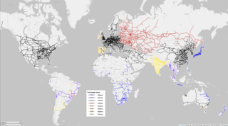
Map of the world's major railways, color coded to show rail gauge, the distance between tracks. Produced using
OpenRailwayMap
, an OpenStreetMap project.
3 ft gauge (914mm)
Meter gauge (1000mm)
Cape gauge (1067mm)
Standard gauge (1435mm)
Russian gauge (1520mm)
Five foot gauge (1524mm)
Irish gauge (1600mm)
Iberian gauge (1668mm)
Indian gauge (1676mm)
|
|||
| Date | ||||
| Source | openstreetmap.org | |||
| Creator |
OpenStreetMap contributors,
user:ArnoldReinhold
"I release my contributions under
CC0
"--
agr
(
talk
) 14:52, 12 September 2022 (UTC)
OpenStreetMap contributors
|
|||
|
Permission
( Reusing this file ) |
OpenStreetMap data is available under the Open Database License ( details ). Standard style map tiles are licensed as ODbL Produced Works.
|
|||
| Georeferencing | If inappropriate please set warp_status = skip to hide. |