Wpdms_shdrlfi020l_death_valley.jpg
No higher resolution available.
Summary
English:
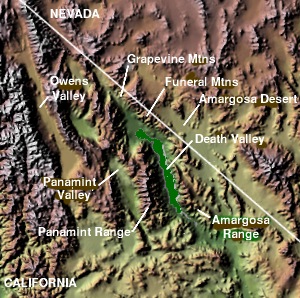
Topographic map of
Death Valley National Park
— and surrounding Mojave Desert and Great Basin topography, in California and Nevada.
Uploaded to english wikipedia by Matthew Trump under GFDL 2004. Original copyright claimed by the uploader.
http://en.wikipedia.org/wiki/Amargosa_Desert
Licensing

|
Permission is granted to copy, distribute and/or modify this document under the terms of the GNU Free Documentation License , Version 1.2 or any later version published by the Free Software Foundation ; with no Invariant Sections, no Front-Cover Texts, and no Back-Cover Texts. A copy of the license is included in the section entitled GNU Free Documentation License . |
|
|
This file is licensed under the Creative Commons Attribution-Share Alike 3.0 Unported license. | |
|
||
| This licensing tag was added to this file as part of the GFDL licensing update . |