África_Ecuatorial_Española.svg

Summary
| Description |
Español:
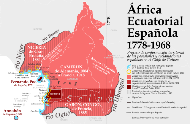
Proceso de conformación territorial de las posesiones y reclamaciones españolas en el Golfo de Guinea, 1778-1968
Fuentes: "Reivindicaciones de España", José María Areilza "Estudios sobre las posesiones españolas del Golfo de Guinea", Julián Pellón y Rodríguez, citado por Francisco de Coello "África: Fragmentos de un Diario de Viajes de Exploración en la Zona de Corisco", Manuel Iradier "La narrativa del africanismo franquista: génesis y prácticas socio-educativas", tesis doctoral de David Parra Monserrat, 2012, citando en la pág. 136 a G. Nerín y A. Bosch, "El Imperio que nunca existió. La aventura colonial discutida en Hendaya", Barcelona, Plaza & Janés, 2001, p. 62 Tratado de El Pardo, 1778 https://es.wikipedia.org/wiki/Tratado_de_El_Pardo_(1778) Tratado de París, 1900 https://es.wikipedia.org/wiki/Tratado_de_Par%C3%ADs_de_1900 Camerún, https://es.wikipedia.org/wiki/Kamerun Fronteras del Camerún, https://es.wikipedia.org/wiki/Kamerun#/media/Archivo:Cameroon_boundary_changes-es.svg Mapa base: Natural Earth (dominio público) |
| Date | |
| Source | Own work |
| Author | Nagihuin |
Licensing
|
|
This file is made available under the Creative Commons CC0 1.0 Universal Public Domain Dedication . |
|
The person who associated a work with this deed has dedicated the work to the
public domain
by waiving all of their rights to the work worldwide under copyright law, including all related and neighboring rights, to the extent allowed by law. You can copy, modify, distribute and perform the work, even for commercial purposes, all without asking permission.
|